 |
| This is how my private map for the upcoming road trip along Route 66 looks like. |
I've added many more information and places, used also different icons, but those might be relevant just to myself and might change, depending on what we find out, which information we're going to take with us along the Mother Road.
Every suitcase represents another stop on our journey - thus you can count the number of hotels between Chicago and LA, we're going to stay. For every of the 8 states Route 66 is passing I added an American Flag icon as silhouette of the USA. Those icons contain general information of the respective State. I marked the MUST SEES with special icons and added quite a bit of information to every single icon on the map. Hard and time consuming work, but I hope it will help us navigate easier from location to location.
The publicly available #InteractiveMap will be completed with information on the go and missing places and information added by the time we get back from our journey. This map will stay private and will hopefully help us get along the Mother Road easier.
I downloaded the Route 66: Ultimate Guide onto my smartphone that would work without Internet connection, but it includes only some of the places we want to see and many other places we are not really interested to go to, but I promised the guy, who created this App, to test it and make suggestions for improvements. The idea behind this smartphone application is really a good one, but I would say it's only the beta version, because also many photos are still missing.
 |
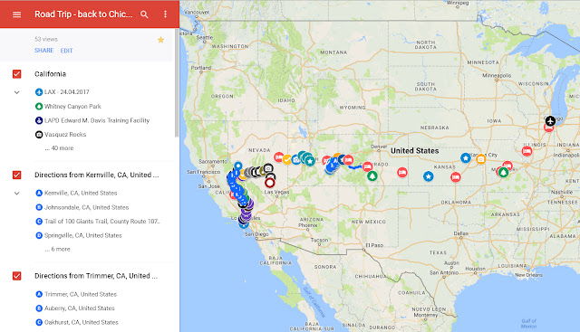
| Also private map - back to Chicago ... |
Initially we wanted to drive the Pacific Coast Highway from LA to SFO and meet some Google friends, but we wouldn't make it back in time. More than two weeks on Route 66, we need some nature and want to do some hiking as well. So we decided on some National, State and Historic Parks. I'll keep you posted in my communities and collections and maybe even in my travels blogs, as time permits. We should have Internet connection at every location, but you know - it might work, but sometimes it wouldn't.
On Google+ you'll find postings in the below communities and collections.
Route 66 Travelers (community in English language)
2017 Road Trip ... US Route 66 (bilingual collection - English/German)
USA Southwest Travelers (community in English language)
2017 Road Trip ... back to Chicago (bilingual collection - English/German)
Might also post on Facebook from time to time or share from one of the above collections or communities onto my timeline there. You can find me under the following link: TimeTraveler 911.
No comments:
Post a Comment